Map
See our video tutorial.
This section displays a map with the current organization’s devices latests known position (GPS or network computed based on Wi-Fi, Bluetooth and cellular network).
Ten filters allow you to search devices: Famoco ID; Fleet; Profile; Sync Status; Model; Heartbeat; IMEI; Labels; Maintenance Status; Owner. The number of devices localized on the map and the number of devices found are displayed top right of the map (“8 devices localized out of 10” when the filter search finds 10 devices, including 8 that can be positioned on the map based on a GPS or Network location). Depending on the zoom level, some positioned devices may also be hidden.
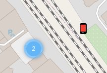
Each device is rendered on the map as a blue device icon. By hovering a device, you can display a tooltip with the device ID and its Owner’s name (if any). You can access a device’s detailed information by clicking on the blue device icon to display the corresponding device side panel.
When several devices are located in the same area, they are clustered and their position is rendered as a coloured circle and a number indicating the number of devices in the cluster. The cluster uses a few shades of blue based on the number of clustered devices (darker when there are more devices). You can click on a cluster to zoom in and display blue device icons and/or sub-clusters. When it is not possible to zoom in or when several devices have the exact same position, clicking on a cluster renders each device icon next to the cluster.
From the device side-panel (in this section or in the Devices section), it is also possible to access directly to the device map by clicking the “see on map” link displayed in the Location section next to the geocoordinates.
The device position is retrieved during each synchronization. If location is enabled on the device and if a position has been computed and stored, then the last stored position is synced and used to render the map. If the device doesn’t send any position during a sync, the last one is kept and continues to be rendered on the map until a new one is received. A Regular location fixes option can be activated in the Profile options to trigger 2 location fixes attempts per sync cycle. The side-panel displays the latitude and longitude coordinates (e.g., “48.85820, 2.33870”), the localization method, accuracy and date (e.g., “GPS accuracy: 12m, Mar 30, 2020, 12:13” or “Network Location accuracy: 100m, Nov 20, 2019, 18:07”).
A device with GPS and/or Network location activated may not report recent positions to MDM because none of its running applications is triggering location fixes. A Trigger regular location fixes MDM Profile option allows to trigger 2 location fixes attempts per sync cycle (e.g., a GPS and/or Network location fix attempt every 15 minutes for a device syncing every 30 minutes). In order to save battery, each location fix attempt is limited to a 1 minute duration and a medium accuracy (100 m), e.g. the device will refine the position until accuracy reaches 100 m (or less) or untill the process has lasted for 1 minute. This feature is available with devices using Famoco Layer v 2.28.0 or above.
It can take up to a few minutes to compute a GPS position and the device sync doesn’t trigger GPS positioning, therefore the synced GPS position is a value stored on the device as the last known position. If there is no recent location fix request (or if the device is in a building and unable to receive satellites signal), the synced GPS position may also be obsolete.
Please note that the map doesn’t render the position computing date (the location date is available in the side-panel), nor the position accuracy (accuracy in meters or kilometers is available in the side-panel). Device position on map can be obsolete and/or inaccurate.
Failing any GPS or Network location position (GPS and Network location are disabled), the device is not positioned on the map but an approximate position is computed based on the device IP during sync and displayed as a city/country text (e.g. “Paris, France”) its side-panel.